Posts

Posts mit dem Label "Blender" werden angezeigt.

Alternative for Aerialod

Bild
First of all what is Aerialod and why do i need an alternative. Aerialod is an tool to create fast 3D voxel images out of height maps. Advantages and Disadvantages of Aerialod Advantages: User-Friendly: Aerialod is an easy-to-use tool for creating 3D terrain models. It caters to both beginners and experienced users who want to achieve results quickly. Freeware but not Open Source: Aerialod is free to download but does not allows users to modify and extend the source code. Variety of Features: Aerialod supports the generation of various terrains, the use of real satellite data, and the creation of synthetic heightmaps. This makes it a versatile tool for different applications in geodata visualization. Disadvantages: Lack of Advanced Features: While Aerialod offers many useful functions, it may lack some advanced features found in professional 3D rendering tools, making it less suitable for certain applications. Not Open Source No new version since 2023. Overall, Aerialod presents an in...

QGIS 3D MAP mit offenen Daten

Bild
Wie man hier im Blog sehen kann, beschäftige ich mich schon seit einiger Zeit mit der Erstellung von Karten für Fotobücher. Bisher habe ich dafür GIMP und Inkscape verwendet. Nun wurde ich zum ersten Mal "gezwungen" mich mit QGIS zu beschäftigen. Auslöser war ein Blogpost von https://opendata.stadt-muenster.de/ über 3D-Gebäudedaten , die für ganz NRW kostenlos zur verfügung stehen. Also habe ich den Urlaub zwischen den Feiertagen genutzt mir verschiede Tutorials über QGIS anzuschauen, damit ich überhaubt was mit den Daten anfangen konnte. Als Testgebiet habe ich die Schleife in Münster Kinderhaus gewählt, da es dort viele Häuser in unterschiedlichen Höhen gibt. Leider war die Qualität der 3D-Gebäudemodelle "LoD1" und "LoD2" schlechter als erhofft. Einige Gebäude fehlten ganz, andere waren nur als Punkte dargestellt, wie man auf diesem Screenshot sehen kann: Was in der 3D-Ansicht natürlich nicht allzu beeindruckend aussah: Zum Glück habe ich dann noch e...

7 methods to get a depth map without exiftool

Bild
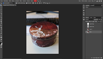
Online Tools Use an online extractor e.g.: Depth Map Extractor or Depth Extractor (both don't work with my example file from the Google Pixel 6a) Use Photopea. Photopea is even able to import all other images inside the metadata. You can use this tutorial or directly go to https://www.photopea.com/ .   Command line Tools Depth-map-extractor an Python script optimised for photos from Huawei  phones. Phonedepth , a small command line tool to extract depth data. Creating not extracting In 3D tools like blender you can simply render the mist pass/depth map and then use it in other programs: AI: There are several AI depth map creation tools. (online and local). The quality varies quite a lot depending on the input image and the used model. Sometimes it looks good at first glance, but is simply wrong. However, the AI models are improving very quickly. But if it is not perfect you can fix it, have a look at the last point. Here for example the not very good output result from 3...

Maps for Photo Books

Bild
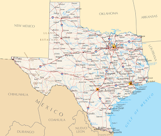
  I love to add maps to the photo books. Here is a collection of some of them.    This is a example of a simple map without the visited places marked. I just added the big Texas label and the overview map of North-America. I used Inkscape and Gimp for this map.    This is a map I made as a title for a calender. I marked the locations from the photos. This image was made with Inkscape. This map is a mix of elements with Gimp extracted from old maps and then composed to a new map in Inkscape.  For this map I got the base image from Mapbox . Then I added the route and some details with Inkscape. To create the route I used Google My Maps , exported it as KML file and converted it to SVG. Here I used a image from the NASA and added the flight route with Gimp and the text boxes with Inkscape. Here I used Blender to create the map. I wrote a longer post here: Low polygon 3D europe map Google My Maps and Inksc...

Low polygon 3D europe map UPDATE

Bild
Here come the promised update. I've added text and the flight routs to the image: This time I'd like to thank the authors of this two YouTube videos to help me with Blender.    1. Text in Blender    2. Curves in Blender

Low polygon 3D europe map

Bild
Hello my latest little project is a 3D low polygon map. I used Blender and Gimp to create this map: I've started with an elevation map of Europe I found on the website from "The European Environment Agency" (EEA). Thank you EU for this image: http://www.eea.europa.eu/data-and-maps/figures/elevation-map-of-europe Then I had to cut of the black border with Gimp and created a second image as height map: For this step I converted the image to black and white and then used the curve tool to make the mountains darker. This will make the mountains in the final image higher and easier to discover. Then I used this tutorial to create the 3D image in Blender: http://johnflower.org/tutorial/make-mountains-blender-height-maps But I didn't  subdivide in as many parts than the tutorial ans I haven't smoothed, because I wanted a low polygon look of my image and not a realistic one. After this step I gave the plane the original colour image as textur...