Posts

Gimp now supports the HGT file format
Bild
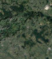
In the latest developer version Gimp (2.9.8) now supports the HGT file format. So what is HGT? That’s topography data basically just containing elevation in meters of various landscape ( HGT stands for “ height “), gathered by the Shuttle Radar Topography Mission (SRTM) run by various space agencies (NASA, National Geospatial-Intelligence Agency, German and Italian space agencies…).  You can read more about the file format in Jehans blog: https://girinstud.io/news/2017/12/new-format-in-gimp-hgt/ Get Gimp >= 2.9.8. Get the HGT file you are interested in. I used this on: https://dds.cr.usgs.gov/srtm/version2_1/SRTM3/Eurasia/N50E014.hgt.zip Unzip the file. Open the HGT file in Gimp.  It is OK, that the file is all gray. Now we have to go to the next step. Edit the HGT file with Colours -> Levels Use the black and white triangles in the "Input Levels" section to show only the interesting data. To be more exact you can open the levels dialogue a second t...

How run Google Cardboard Apps using Google Daydream

Bild
CC BY Maurizio Pesce 1. Opened up the settings on my phone 2. Turned off NFC (I'm not sure if this is really needed.) 3. Opened the Google Cardboard App I wanted to play 4. Got an Dialogue with "Incompatible App - This Cardboard-App is not compatible with Daydream-Headsets" 5. Clicked on Cancel -> The app closed 5b. Clicked on connect device -> got a screen to scan a QR-Code 6. Scan this QR-Code: 7. Put my phone into the headset 8. It worked.

darktable geoToolbox Script

Bild
Last year I blogged about the KML and the geoJSON export scripts for darktable . I've wrote an other script for darktable, the geo toolbox and it looks like this: I'd like to describe the functionality here short: Button 1 and 2: With this two buttons you can select all images with or without location information in the Exif tag. Button 3 and 4: With this button you can copy GPS information from one iomage to an other. With the checkboxes you can select which part of the GPS information you like to copy. Button 5 [open in Gnome Maps]: This button opens Gnome Maps and shows the position of the photo in the map. Button 6 [reverse geocode]: This function is still not very useful. It uses a web-service from Mapbox to get information from OpenStreetMap about the place of the selected photo and shows this in an info window. Button 7 [export altitude CSV file]: This function exports a CSV file from the selected images with the altitude in meters i...

Lenovo Moto Z Wifi problem

Bild
If you owe a Lenovo Moto Z and it can't find your WLAN you should check if your WLAN uses the channel 13. If yes, just change it and your phone will find the WLAN, because the Moto Z is not able to use the channel 13..

Google Earth from a Tool to a Toy

Last week Google release a new version of Google Earth. Google made a complete rewrite from a classical client to a web client. Really new and nice are only the interactive guided tours. This new client has a lot of drawbacks: It only runs in Google Chrome No Google Moon No Google Mars No Panoramio No Wikipedia links No historical images  No measurement tools I can't create new tours. The KML import is experimental and broken  No more creation of videos And I'm not alone, other peole are as disappointed as m: http://www.i-programmer.info/news/145-mapping-a-gis/10692-google-earth-reduced-to-a-divisive-toy.html

The Hardware is good, but the Software sucks - Update

Bild
I have a new GoPro HERO5 Black the hardware is really nice Voice Control 2-inch Touch Display Simple One-Button Control Rugged + Waterproof 4K Video / 12MP Photo Not so cool is: USB door stupid hard to open. Cannot use camera in time lapse and charge at same time. But the software has really some problems: No RAW support in timelapse mode ( Update: This is now possible with the latest firmware update) The GPR (RAW) format is an extension to Adobes DNG format, adding enhanced compression.  Using standard DNG with non-standard "enhanced" compression. Nice, now only Adobe is able to open this images. No Linux tool is at the moment able to open the images. The GoPro Desktop and Mobile Apps are only usable with creating an online account. The GoPro Developer Program /SDK costs $99/yr GoPro use a lot of open source tools[1], but treads other developers like shit. [1] https://gopro.com/help/articles/block/Open-Source-Software You can't update ...

What I don't like about my new Samsung Galaxy A5 (2016)

Bild
I got a Samsung Galaxy A5 (2016) and I'm a little bit disappointed, because: Samsung has not implemented the camera2 API. Normaly every phone with Android > 4.4 should have this API. It gives the developers of photo apps more control about the camera. The Samsung Galaxy A5 has Android 7, but Samsung simple had not implemented this API. This is the reason why Samsung has to ship it with a custom camera app and does not include the Goggle camera app the the fancy deep of field refocus feature. (More infos here: https://dablogter.blogspot.de/2014/04/googles-new-camera-app-update.html) The second disadvantage is that the phone has no gyroscope. But without a gyroscoe it is not possible to use the phone with Goggles Cardboard is a virtual reality (VR) platform and the low-cost Cardboard viewer. If you are interested in photographing or in Goggles Cardboard virtual reality (VR) platform, you should not by this phone.