Posts

The Hardware is good, but the Software sucks - Update

Bild
I have a new GoPro HERO5 Black the hardware is really nice Voice Control 2-inch Touch Display Simple One-Button Control Rugged + Waterproof 4K Video / 12MP Photo Not so cool is: USB door stupid hard to open. Cannot use camera in time lapse and charge at same time. But the software has really some problems: No RAW support in timelapse mode ( Update: This is now possible with the latest firmware update) The GPR (RAW) format is an extension to Adobes DNG format, adding enhanced compression.  Using standard DNG with non-standard "enhanced" compression. Nice, now only Adobe is able to open this images. No Linux tool is at the moment able to open the images. The GoPro Desktop and Mobile Apps are only usable with creating an online account. The GoPro Developer Program /SDK costs $99/yr GoPro use a lot of open source tools[1], but treads other developers like shit. [1] https://gopro.com/help/articles/block/Open-Source-Software You can't update ...

What I don't like about my new Samsung Galaxy A5 (2016)

Bild
I got a Samsung Galaxy A5 (2016) and I'm a little bit disappointed, because: Samsung has not implemented the camera2 API. Normaly every phone with Android > 4.4 should have this API. It gives the developers of photo apps more control about the camera. The Samsung Galaxy A5 has Android 7, but Samsung simple had not implemented this API. This is the reason why Samsung has to ship it with a custom camera app and does not include the Goggle camera app the the fancy deep of field refocus feature. (More infos here: https://dablogter.blogspot.de/2014/04/googles-new-camera-app-update.html) The second disadvantage is that the phone has no gyroscope. But without a gyroscoe it is not possible to use the phone with Goggles Cardboard is a virtual reality (VR) platform and the low-cost Cardboard viewer. If you are interested in photographing or in Goggles Cardboard virtual reality (VR) platform, you should not by this phone.

Low polygon 3D Europe map UPDATE 2

Bild
As the "Low polygon 3D Europe map" tutorial is on of the most read posts I have some more information for you.   1. Here you can download a complete land topography of the world as a digital image of the three-dimensional structure of the Earth's surface: http://visibleearth.nasa.gov/view.php?id=73934  2. The link to "Open Digital Elevation Model (OpenDEM)". You can use this data to create an similar image. (I haven't done this. It looks like a lot of work.) http://www.opendem.info/index.html 3. Somegeneral information about Digital elevation models: https://en.wikipedia.org/wiki/Digital_elevation_model The two older post in this series:  Low polygon 3D Europe map Low polygon 3D europe map UPDATE

Tutorial: Creating maps from geo tagged photos

Bild
If your camera is able to add gps coordinates to the photos you can use darktable to create a KML or geoJSON files with thumbnails of the photos. Install the latest version of darktable: https://www.darktable.org/install/ Get the latest version of the KML or geoJSON script: https://github.com/darktable-org/lua-scripts/tree/master/contrib Copy the scripst into the folder: ~/.config/darktable/lua Add this lines to the file: ~/.config/darktable/luarc require "kml_export" r equire "geoJSON_export" Import the photos into darktable: https://www.darktable.org/usermanual/ch01s03.html.php#d0e788 Edit the settings: Select all photos you like to have in the KML or JSON file. Export the photos:   And this are the results of the exports The KMZ opened in Google Earth The KMZ opened in KDE Marble The HTML file, that renders the geoJSON with the help of MapBox .  (To get the map rendered you need a MapBox account and insert the ...

Tutorial: How do I get Google Maps routes into Inkscape?

Bild
1. Create a new map with Google My Maps: 2. Create a route:  3. Export as KML  4. Go to http://indiemapper.com/app/ (The link does'n work any longer) and import the KML file:  5. Use the export button to export it to SVG:  4. / 5. Update: Use https://mygeodata.cloud/converter/kml-to-svg  to convert the KML to SVG.  6. Open the file in Inkscape

Maps for Photo Books

Bild
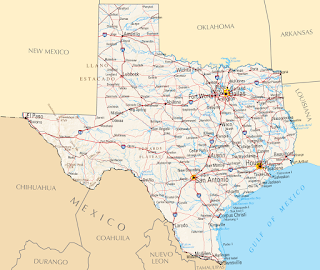
  I love to add maps to the photo books. Here is a collection of some of them.    This is a example of a simple map without the visited places marked. I just added the big Texas label and the overview map of North-America. I used Inkscape and Gimp for this map.    This is a map I made as a title for a calender. I marked the locations from the photos. This image was made with Inkscape. This map is a mix of elements with Gimp extracted from old maps and then composed to a new map in Inkscape.  For this map I got the base image from Mapbox . Then I added the route and some details with Inkscape. To create the route I used Google My Maps , exported it as KML file and converted it to SVG. Here I used a image from the NASA and added the flight route with Gimp and the text boxes with Inkscape. Here I used Blender to create the map. I wrote a longer post here: Low polygon 3D europe map Google My Maps and Inksc...

darktable export script to Hugin

Bild
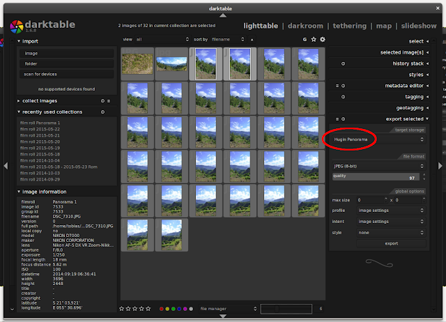
I improved the darktable Lua script to export images directly from darktable to Hugin , to use the new command line tool from Hugin 2015.0.0:   https://github.com/darktable-org/lua-scripts/blob/master/contrib/hugin.lua